
The “Centro Ciência Viva do Lousal” installed a meteorological station in Lousal on December 14th, 2021. The acquisition of this device, planned by LIFE RIBERMINE, will allow the recording and analysis of various climatic variables – in particular precipitation and temperature -, a very faithful knowledge of the local climate regime, and its correlation with various physical and geophysical aspects occurring in the intervened area (Lousal Pilot Project), namely the evolution of relief, soil moisture, vegetation development, shapes erosion, among others.
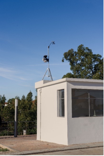
Lousal meteorological station – LIFE RIBERMINE, installed in the former “house of the balance”. Foto: @BrunoGonçalves
The climatic characterization is extremely important, and the selection of flora species for the ecological restoration Works, took into account their adaptation to local and regional climatic conditions.
Since to date there were no specific data for the Lousal location, for the current climate characterization, prepared for the Lousal Restoration Plan (document that gave the guidelines for the implementation of the Lousal Pilot Project) were consulted and crossed data from different sources (“Sheet 42-B Azinheira de Barros”, data from the meteorological stations of the National Water Resources Information System, SNIRH, for the period between 1982 and 2007, and, the “Revision of the Municipal Master Plan of Grândola , Characterization Plan”, 2015). The series of observations from four stations of the “Instituto Português do Mar e da Atmosfera”, IPMA, IP were used: Alcácer do Sal, Grândola, Santiago do Cacém and Alvalade.
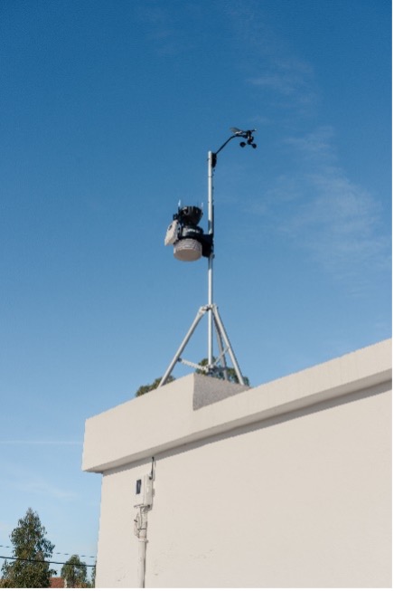
Lousal meteorological station. Foto: @BrunoGonçalves
Using data from the Climatological station of Grândola and the Udometric station of Azinheira de Barros, the climatological balance of water in the soil (considered a usable water capacity of 100mm) and the annual value of actual evapotranspiration (EVR) were calculated. According to MENDES & BETTENCOURT (1980), this area presents an average rainfall between 595.3mm/year and 530.2mm/year, which decreases from West to East (Lousal is located to the East), with a strong water deficit in the Summer. The climate is classified as Sub-humid Dry, 2nd. Mesothermal, with moderate water deficit in summer and little thermal efficiency in this season.
For the Azinheira de Barros station, the period of greatest precipitation is verified in the quarter from October to December, with 47% of the annual precipitation. The annual average air temperature is 16.2ºC, with lower monthly average values from December to February (about 9º – 10ºC), and higher values from June to September (20º – 23ºC).
Every month they present average temperature values above 10°C (below this threshold the metabolic balance of the vegetation cover becomes negative). The low thermal amplitude between the coldest months (December and January, with average temperatures of 10.1 °C) and the hottest month (August, with 22.6 °C), of 12.5 °C, denoting the effects of the thermal inertia of the neighboring ocean.
In the Grândola Ombrothermic Diagram, prepared in accordance with RIVAS-MARTÍNEZ (2005), which contains the crossing of precipitation and temperature data, over the months of the year, it is possible to confirm the variation in water availability for the vegetation cover: when the bars (or lines) of precipitation are below the temperature line, the soil on the half slopes suffers from a water deficit, with more water available whenever the opposite situation occurs.
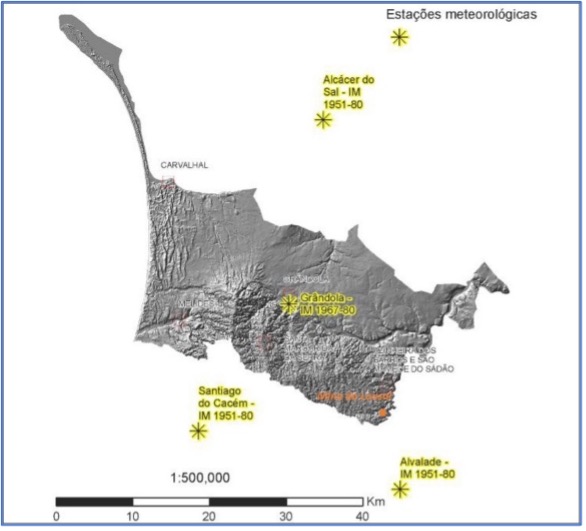
Location of the climatological stations used for the climatic characterization of the municipality of Grândola (adapt. from: “RPDMG-PC”, CMG, 2015”).
It is observed that from March to September (the hottest months of the year) the temperature line (in red) exceeds that of precipitation (in blue), reflecting high evapotranspiration and soil moisture deficit. In climatological terms, the region is characterized by great water shortages, with scarce rainfall and a water deficit in the hottest months of the year.
According to COSTA et al. (1999) we can detect the Mediterranean pattern of a climate, through the coincidence of the hot period of the year, with its driest period, which always gives rise to months in which the temperature curve has values higher than the precipitation curve (the so-called months dry).
Thus, Grândola Ombrothermic Diagram denotes a characteristic Mediterranean-type climate that is characterized precisely by the occurrence of at least 2 months in the year when the temperature is higher than the precipitation (P> 2T). These dry season months coincide with summer, being those in which fires are more likely to occur in ecosystems, conditioning agricultural and forestry activities. In other seasons of the year, an excess of water can occur.
The rainfall in the south of the municipality of Grândola is worthy of note. Although precipitation on the lower slopes of the Serra de Grândola is abundant, as will be detailed below, the fact that they are covered with skeletal soils (or litosoils, according to the Portuguese pedological classification), inhibits the storage of water in the topsoil (its field capacity for retention is reduced), conditioning the availability of this resource to the vegetation cover. On the other hand, Lousal has geographic particularities, which give it a lower availability of precipitation, with sporadic episodes of torrential rain, in short and very intense periods, with the seasons of greatest water shortage predominating throughout the year. This also enhances phenomena such as erosion.
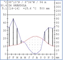
Grândola Ombrothermic Diagram (adapted from: “RPDMG-PC, 2015”).
According to the World Bioclimatic Classification System (RIVAS-MARTÍNEZ, 1996-2009), practically all of southern Portugal (except for two areas in the Algarve) is located in the Oceanic Pluviestational Mediterranean Bioclimate. Also according to this Classification System, it is located in the Thermo-Mediterranean Thermoclimatic Belt.
In the municipality of Grândola, the “Mesomediterranean” and “Thermo-Mediterranean” thermotypes occur: the former predominates in the Serra de Grândola, with higher altitudes; the Thermo-Mediterranean Thermotype occurs in the lowlands, including Lousal which corresponds to the Superior Thermo-Mediterranean Thermotype.
In the municipality of Grândola, the Ombrotypes “Sub-humid” (annual precipitation between 1000mm and 600mm) occur in the Grândola mountain range, with higher altitudes, and “Seco” (annual precipitation between 600mm and 350mm) in the rest of the territory, of lowlands. Thus, Lousal is included in the Upper Dry Ombrotype.
With the installation of the meteorological station in Lousal, which is intended to become part of the National (Portuguese) Network of Meteorological Stations, it will be possible to obtain specific data about the location, and also create an interactive module at CCVLousal – LIFE RIBERMINE, aimed at the Climate, where the public will be able to explore the data that will be continuously sent to a computer, and learn more about these matters.
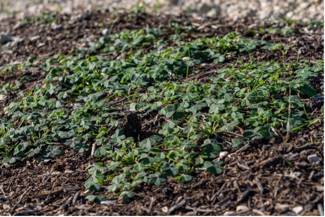
Water availability is essential for the development of the vegetation cover. The photo shows some plants that have already germinated, from the sowing carried out in late October, in the area of the Lousal Pilot Project. Photo: @BrunoGonçalves
Consulted bibliography
– CMG (CÂMARA MUNICIPAL DE GRÂNDOLA) (2015) – “Revisão do Plano Diretor Municipal de Grândola, Plano de Caraterização – RPDMG-PC”.
– COSTA, J.C., AGUIAR C., CAPELO, J., LOUSÃ, M. & NETO, C. (1999) – “Biogeografia de Portugal Continental”. Quercetea 0 :5-56.
– MARTINS, M., SÁNCHEZ DONOSO, R., MARTÍN DUQUE, J.M.F., MARTÍN MORENO, C., LILLO RAMOS, F.J., TEJEDOR PALOMINO, M., VILLA ALBARES, J., PEREIRA, A.M., OLIVEIRA, M., PAIS, V., COSTA, J., PINTO, A.M. & RELVAS, J.M.R. (2021) – “Plano de Restauração do Lousal / LIFE RIBERMINE”. CCVLousal. xiv + 166 pp. ISBN: 978-989-54904-0-0
– MENDES, C. BETTENCOURT, M.L. (1980) – “O clima de Portugal. Contribuição para o estudo do balanço climatológico de água no solo e classificação climática de Portugal continental”. Instituto Nacional de Meteorologia e Geofísica, XXIV, 287.
– OLIVEIRA, J.T., FERNANDES, P., PAIS, J. & DIAS, R. (2013) – “Notícia explicativa da folha 42-B Azinheira de Barros”. Unidade de Geologia e Cartografia Geológica, Laboratório Nacional de Energia e Geologia. Lisboa, 48 pp.
– RIVAS-MARTÍNEZ, S. (2005) – “Memoria del Mapa de Vegetación de España”. Itinera Geobotánica 17. Universidad de León.
– RIVAS-MARTÍNEZ, S. (1996-2009) “Sistema de Clasificación Bioclimática Mundial”. Centro de Investigaciones Fitosociológicas, Madrid (http://webs.ucm.es/info/cif/form/maps.htm)